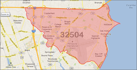
Our ZIP Code Boundary Data adds perspective to your maps, points you towards the good potential customers, adds relevance to your local search and:
- Is available for Immediate Download. Working on a Saturday and need this data right now? No problem!
- Is sourced from the USPS, then enhanced and improved using proprietary processes.
- Is compiled with strict methodology and algorithms that align ZIP Code data with streets to eliminate overlaps.
- Is comprehensive, providing coverage across the entire United States including Washington DC and Puerto Rico.
- Is complete with latitude/longitude for all ZIP Code polygons, and ZIP Code centroids.
- Is easy to integrate with other datasets, including Neighborhood Boundaries, County Boundaries, City Boundaries, and other GIS databases.
- Is updated every quarter, not yearly like other sources.
- Is current USPS defined ZIP Codes, not ZCTA boundaries
- Is continuous Coverage! Unlike others who have gaps in their boundaries for areas not covered by a ZIP Code, we have filler Polygons that ensure full coverage of the United States.
- Is available in multiple major GIS formats:
- ESRI - Shapefile (.shp)
- Google Display - KML (.kml)
- DB Loadable - WKT (.txt)
- DB Loadable - MySQL™ (.sql)
- DB Loadable - SQL Server (.sql)
- DB Loadable - Post GIS (.sql)
- Comma Separated Values (.csv)
Data Fields:
You get more than just the boundaries. These are just some of the data fields also included:

- Name
- ZIP Code Type
- State
- County
- State & County FIPS
- Centerpoint Latitude & Longitude
- Residential Delivery Count
- Business Delivery Count
- P.O. Box Delivery Count
- Single Family Delivery Count
- Multi Family Delivery Count
- Color (for easy mapping)
- See More
Use ZIP Code Boundaries:
- To see customer data with actual boundaries for the ZIP Code being shown.
- In your own web mashup or interactive map application on the web.
- For lead assignment or for routing leads to sales reps or distributors.
- To add ZIP Code layers to your existing Geographic Information System (GIS) such as ESRI's ArcView or MapInfo.
- For internal data analysis of customers, vendors, or any segment imaginable.
- For real ZIP Code boundaries, not a ZIP Code Tabulation Area (ZCTA) like most sites provide from the Census Bureau.